
The plan for today was to paddle from Macquarie Heads to Betsys Bay and then walk over to the beach on the West Coast near Sloop Point.
And as I pulled up at the boat ramp at Macqwuaire Heads, I was rather pleased with myself having thought I had timed my departure to perfection.
It was just after 9:00am and according to my tide charts it should be about 2 hours after low tide, which means there should have been a nice incoming flow of water coming through Macquarie Heads ready to sweep me down to Betsys Bay with barely a paddle needing to go in the water.

Which was why it was quite alarming to get out of my car and walk out onto the jetty only to notice that there was definitely a fast flowing current flowing past the jetty … but it was flowing out towards the heads, not in towards the harbour.,
And it was flowing fast.
Then there was also the small matter of what I now know to be Pelican Spit and Fraser Flats … a massive sand bank blocking passage across the kelly channel for nearly as far as I could see in either direction. Why hadn’t that come up in any conversations with anyone when I was seeking advice on paddling across the heads? (postscript – turned out I had been warned several times when I went back and checked emails, it just hadn’t registered on me what people were talking about when they talked about “Pelican Spit”).
Seemed the options were to paddle out towards the heads, with the strong current, and then hope to get across without gettting swept out to sea (not inviting) or paddle inside the flats up into the harbour and hope I could get across somewhere upsteam (also not inviting).
So, instead I sat there and looked up and down the heads wondering what to do.
Fortunately, there was a marine cop parked nearby, so I wandered over and had a chat and after telling him my plans for the day, he firstly assured me that there was in fact no walking track from Betsys Bay over to the coast so I was wasting my time, but then said that if I insisted on going , he recommended that I paddle out towards the heads and cross over that way.
Then he immediately changed his mind and told me to instead paddle along the back channel towards River Point (although he just pointed to a sandy hill – I figured out the name later) and then cut across once I was past the sandbanks.
I may be over-reading it, but there seemed to be an imputation that at least if I go this way, if things go wrong, the worst that should happen is I’ll get carried back to the boat ramp, whereas if I go the other way … well, it’s a big ocean out there.
Oh … and he assured me that the water flow through the Heads is largely unaffected by the tidal movements, and far more affected by atmospheric pressure changes and prevailing weather. Advice, several others have subsequently confirmed.
So with that ringing vote of confidence, I got my gear sorted out, and launched onto the water.
I was very pleased to see I was able to make headway against the current, but for some reason decided that despite the advice I had been given, maybe I would be able to just cut across between the sandflats and not need to go all the way around as had been suggested.
Several attempts (and several strandings later) I realised that there were no deep channels cutting through the sand bank, so I instead commenced the inside loop to get around them and eventually cut across to one of the navigation beams and from there headed across to Backagain Point.

I should probably say at this juncture that the plan for today had been to paddle down to Betsy’s Bay and see if I could find a track (which you can still see on the TasMap baselayer on Listmap) which takes you over to the west coast about 2.5kms north of Sloop Point. The walk looked to be about 4kms each way, and with a paddle of around 16kms return to Betsy Bay, it all looked on paper to be a do-able day trip.
And much to my relief given the police officers, previous advice, As I paddled into Betsys Bay I came around a last little headland to see a big stretch of beach in front of me and what looked to be an obvious landing point (big pole in the water with a rope hung up behind it) and most importantly I could see what looked to be sections of a track heading up from there … all looking very hopeful.
I was soon landed beside what looked to be a nice campspot which could easily take 3 or 4 tents (and probably a couple more at a squeeze) and just past the campsite I spied the start of the track, so a quick change of clothes later, I set off to explore …
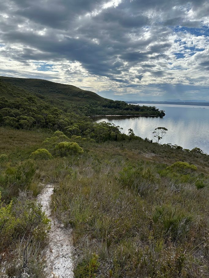
After an initial climb out of the bay, the track lead through some button grass plains, which was a bit overgrown in places but never difficult to follow. After a few small creek crossings and a couple of kms, the ocean on the other side came into view. It was still quite a walk to get there from this point, though this half of the walk was through some interesting heathland and although it took me nearly 90 minutes to walk across, You could get lost if you tried, but I found the track pretty easy to follow overall, but I never found it hard and really enjoyed the whole trip.
Still, it was nice to finally get a good view of the beach … though just as I did the rain came in.
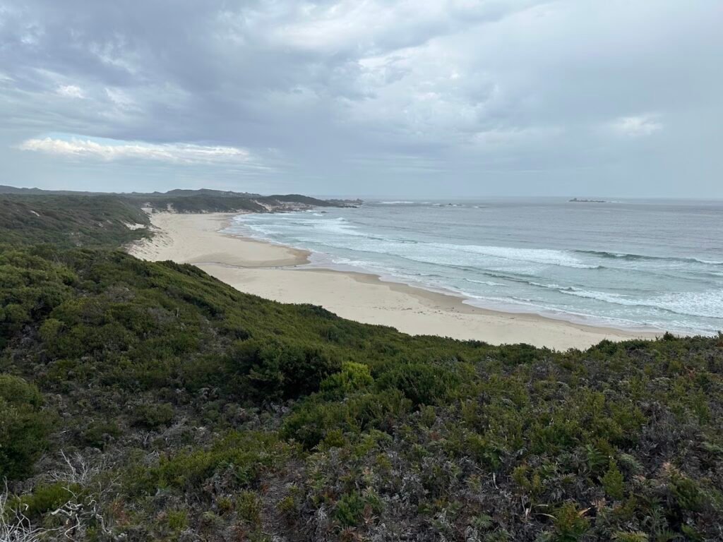
The last section down onto the beach is a steep descent down a sand dune, but fortunately when I was there, there was a rope to help the descent / ascent.
The beach itself was kind of confronting with the sheer volume of washed up bouys, nets, ropes and other garbage scattered across it, though it was lovely to see the sheer number of birds everywhere.

It was around 2pm at this point, and the rain showers and ticking clock led me to abandon any ideas of exploring further down the coast to sloop point, so instead I had a bit of a wander around the northern section of the beach, ate my lunch by the small creek, and then turned around for the return trip.

The helpful rope I was going to use to get back up the dunes broke the moment I put some weight on it, but I was able to quickly fix it and use it to get back up the dune which I’m pretty grateful for.
It was a pretty wet walk back over (lots of rain) which was kind of nice as it gave the whole area a new look on the way back, but I was still happy to get back to the kayak as time was ticking away and I really wanted to get back to the boat ramp at Macquarie Heads before it got dark.
Which is why you can imagine my extreme lack of amusement when I got my wet paddling gear off the tree branch I had hung it on at the camp, threw them on only to feel a small itch, and then another, and then a sting … and then I realised my clothes were covered in tiny biting ants.
What followed was a very ungraceful dance as I threw all my clothes off again and tried to rid myself and all my clothes of a very angry army of biting ants. After what I realised was a losing battle trying to get them off my clothes, I eventually gave up and just threw my paddling clothes onto the front of my kayak (outside, under the bungees) and paddled home in my wet walking gear.
Feeling a bit tired at this point, I slowly paddled away from the beach waiting for the arms and upper body to warm up a bit for the paddle back and desperately hoping that the water was still flowing outwards to give me a nice assisted paddle home.
It wasn’t.
As I came around Backagain Point into the main harbour I could see a definite flow of water around the rocks back into the harbour, but fortunately it didn’t look that strong, so without giving it much thought I paddled onwards on a course towards the marine marker I had passed on the way here.
Now I have recently done the Paddle Australia Sea Skills course and one of the lessons it taught was to compare the point you are heading towards in the mid distance to something further in the distance to see how you course is being affected my wind and currents, so I lined up the marine marker with a mountain peak in the background and very quickly noticed that the relative bearings were changing alarmingly quickly.
I adjusted my course to compensate, but soon realised that I was still being swept into the harbour.
The Harbour is actually pretty shallow at this point with clear water over a sandy bottom, so I was also noticing seaweed and other items in the water below me flashing past increasingly quickly as I paddled further and further out into the main flow, and about half way across to the marker, I found myself in a full out 80-90% peak sustained effort as I was almost ferry gliding across the stream to maintain my direction and forward motion.
There was even a moment when I honestly thought I may not make it to the marker and may need to instead focus on a controlled paddle across to Macquaire Heads in the hope of hitting land while I could and then waiting out the current flow or looping around into Swan Basin and walking back to my car, but fortunately a last 5 minute push managed to get me the last couple of hundred metres to the marker (inch by slow inch) where I was able to hold onto the ladder and take a small rest break and get some food in before continuing over the sand flats (with the current flow now slowing a bit) and eventually cruise back into the boat ramp just as the sun was starting to set …

Thirty minutes later I was warm and dry, and thanks to the nice caretaker, I had my tent set up in a quiet little spot away from other campers where I was able to have a great nights sleep before heading into Strahan the next morning for breakfast.
All up, a great day, though I would like to come back sometime and explore the coast more … maybe heading over on the other (longer) track near the Butt of Liberty to the West Coast next time and spending more time exploring, but still really glad I overcame that moment when I was standing by the boat ramp early in the day thinking “Oh, maybe I shouldn’t do this” and still did it anyway.